Chimanimani National Park: Travel Guide to Zimbabwe’s Mountain Wilderness: History & Culture
Discover Chimanimani National Park: Travel Guide to Zimbabwe’s Mountain Wilderness
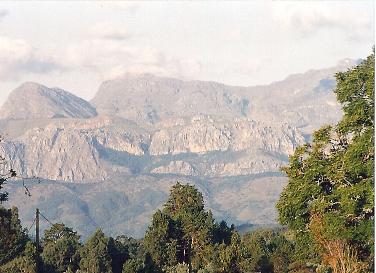
Chimanimani National Park is a 17,110-hectare wilderness of rifted quartzite peaks in the southernmost part of Zimbabwe’s Eastern Highlands, about 150 km from Mutare. Its highest points reach 2,440 m and its ridge line runs for some 50 km along the Mozambique border. With few roads and almost no vehicle access inside the park, it is one of Zimbabwe’s genuine hidden gems: a hiking and botanical destination rather than a safari one, seen by a fraction of the visitors who reach Victoria Falls or Great Zimbabwe.
Chimanimani at a glance
- Country: Zimbabwe
- Province: Manicaland
- Size: 17,110 hectares (about 171 km²)
- Highest point: 2,440 m, part of a quartzite ridge running about 50 km along the Mozambique border
- Distance from Mutare: about 150 km
- Best time to visit: the dry season, May to October, with March-April and August-September rated especially good
What makes it special
The park holds 2,182 recorded plant taxa, more than 30% of Zimbabwe’s total plant diversity, and 74 species found nowhere else. Birdlife is a particular draw, with montane and forest species, including some endemic to the Eastern Highlands, alongside raptors, sunbirds, turacos and forest warblers. Mammals are present but modest in number and hard to see in the dense terrain: blue duiker, bushbuck, samango monkey, leopard and serval among them. Bridal Veil Falls is one of the park’s named natural features, and trout, introduced to its rivers about a century ago, still draw anglers.
Hiking trails and Mountain Hut
Most hikes begin at the park’s base camp and climb roughly 2 to 3 hours up a route called Bailey’s Folly to Mountain Hut, a communal refuge at 1,630 m with basic cooking and ablution facilities for up to 20 hikers sharing the space overnight. Several routes lead up to the hut besides Bailey’s Folly, including Banana Grove Track, the easiest at 30 to 50 minutes, Long Gully and the notably tough Hadange route, so parties can vary their ascent and descent. From the hut, trails fan out to further landmarks: Skeleton Pass, a dramatic saddle between peaks roughly 8 km from base camp and named for the bones of animals that once perished there in bad weather, and Turret Towers, a cluster of peaks that involves scrambling rather than simple walking. None of this is waymarked to the standard of a developed trail network, which is part of why a local guide is strongly recommended for anyone heading beyond the well-trodden Bailey’s Folly route.
Cyclone Idai and recovery
On 15 March 2019, Cyclone Idai struck the wider Chimanimani district with torrential rain and high winds, triggering flooding and landslides that killed at least 169 people in the district and badly damaged roads, bridges, power and water infrastructure, along with some of the area’s tourism lodges. The cyclone reshaped parts of the landscape, and recovery of the district’s roads and infrastructure has continued in the years since; visitors should check current road conditions into Chimanimani village before travelling, since the cyclone’s effects on rural access routes have not all been fully repaired.
Getting there and getting around
Chimanimani village, the gateway to the park, lies about 120 km south of Mutare by road. Inside the park itself, roads are few; hiking is the main way to explore, and the park particularly suits hikers, birdwatchers, botanists and anglers rather than those looking for a drive-through safari.
Planning your visit
Because the park has few facilities and little vehicle access, most visitors base themselves in or near Chimanimani village and walk in for day hikes or overnight trail trips. Pack for a genuinely wild, lightly developed park: this is a hiking and nature destination first, with none of the lodge infrastructure of Zimbabwe’s bigger safari parks.
Where to stay
No stay in or near Chimanimani was verified to the site’s 4.0+/10+ review standard in this research pass, so none is listed here yet; we will add one once we can confirm a rating.
Frequently asked questions
How big is Chimanimani National Park and where is it?
Chimanimani National Park covers 17,110 hectares (about 171 km²) in Zimbabwe’s Manicaland province, roughly 150 km from Mutare. Its highest point reaches 2,440 m, and its quartzite ridge line runs about 50 km along the Mozambique border.
What makes Chimanimani’s plant and bird life special?
The park holds 2,182 recorded plant taxa — more than 30% of Zimbabwe’s total plant diversity — including 74 species found nowhere else on Earth. Birdlife is a particular draw, with montane and forest species, some endemic to the Eastern Highlands, alongside raptors, sunbirds, turacos and forest warblers.
What hiking trails does Chimanimani offer?
Most hikes climb roughly 2 to 3 hours from base camp up the Bailey’s Folly route to Mountain Hut, a communal refuge at 1,630 m sleeping up to 20 hikers. Alternative routes include Banana Grove Track (the easiest, 30–50 minutes), Long Gully and the notably tough Hadange route. From the hut, trails continue to Skeleton Pass and the scramble-grade Turret Towers.
How did Cyclone Idai affect Chimanimani?
On 15 March 2019, Cyclone Idai struck the wider Chimanimani district with torrential rain and high winds, triggering flooding and landslides that killed at least 169 people in the district and badly damaged roads, bridges, power and water infrastructure. Recovery has continued in the years since; visitors should check current road conditions before travelling.
When is the best time to visit Chimanimani?
The dry season, May to October, is best, with March–April and August–September rated especially good.
Where do visitors stay near Chimanimani National Park?
Most visitors base themselves in or near Chimanimani village and walk in for day hikes or overnight trail trips — this is a lightly developed hiking and nature destination, without the lodge infrastructure of Zimbabwe’s bigger safari parks.
Bridal Veil Falls, quartzite peaks to 2,440 m, hiking trails, trout fishing, endemic montane birdlife